


-
 Explore Course Categories
- Explore Course Categories
-
Engineering and Construction

91 Courses -
Personal Development

111 Courses
-
 Explore Careers Categories
-
 All Courses
-
 Get Adams Premium (Remove Ads)
-
 Adams Blog
-
 Resume Builder
-
 Adams For Business
-
 Download the Adams App
Welcome Back!
What will you learn today? Find out with Adams Academy
Sign Up For Free
Join the World's Largest Free Learning Community

-
Welcome Back!
- Don't have an Adams account? Sign Up
or -
Sign Up For Free
Join the World’s Largest Free Learning Community
- Already have an Adams account? Log In
orThis is the name that will appear on your Certification
-
Forgot password?
Please enter you email address and we will mail you a link to reset your password.


This course includes:
-
 3 hours, 1 minute
 -
 CPD Accreditation
-
 7 units
-
Full lifetime access
-
 Access on mobile and TV
-
 Certificate of completion
Share:


course plublisher
Course CloudLearning Outcomes:
- Develop an understanding of the principles and practices of land surveying, including using specialised equipment and techniques.
- Acquire knowledge of relevant laws, regulations, and standards related to land surveying.
- Enhance critical thinking to evaluate land survey data and make informed decisions related to land use and development.
- Gain proficiency in using computer software and other tools to manage and analyse land survey data.
- Improve communication mastery to convey survey data and results to clients and stakeholders effectively.
- Learn to incorporate ethical and professional standards into land surveying practices.
- Develop an appreciation for the historical and cultural significance of land surveying in shaping land use and development.
- Enhance problem-solving skills to address challenges related to land surveying projects.
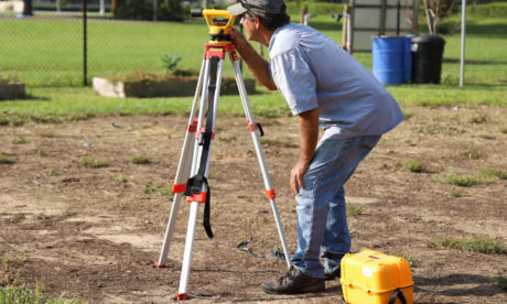
Course Description:
The Land Surveying course is created to provide an understanding of the principles and techniques of land surveying. This undefined covers various topics such as geophysics measurements, topographic surveying, bound surveying, and construction surveying. Individuals wish to instruct about the equipment used in land surveying, such as tally stations, GPS, and optical maser scanners. Additionally, the course highlights the significance of accuracy and precision in land surveying, as well as the grandness of ethical and professional personal conduct. The undefined aims to equip individuals with the knowledge to execute accurate and reliable land surveying.
Course Benefits:
The Land Surveying course can benefit individuals interested in following a career in set-down surveying or related fields. By pickings this course, individuals will better understand the principles and techniques of land surveying and learn how to apply surveying equipment effectively. This noesis can help individuals execute accurate and reliable set-down surveying, which is crucial for various applications such as construction, land development, and resource management. Furthermore, individuals will take in a deeper understanding of the importance of ethical and professional personal conduct in land surveying, which can serve them to build a reputation for dependableness and trustiness in the industry. By the end of the course, individuals will be able to apply their knowledge of land surveying in real-world situations and contribute towards the increase and development of varied industries.
Career Path:
- Land Surveyor: responsible for conducting land surveys, including boundary surveys, topographic surveys, and construction surveys.
- Geographic Information Systems (GIS) Specialist: responsible for managing and analysing geographic data related to land use and development.
- Cartographer: responsible for creating maps and other visual representations of land survey data.
- Land Use Planner: responsible for developing and implementing land use plans and policies for municipalities and other organisations.
- Engineering Surveyor: responsible for conducting surveys related to civil engineering projects, such as roads, bridges, and buildings.
- Remote Sensing Specialist: responsible for using satellite and other technologies to collect and analyse data related to land use and development.
- Real Estate Appraiser: responsible for determining the value of land and buildings based on land survey data and other factors.
Course content
-
 Module 01: Introduction to Land Surveying 00:24:00
 -
Module 02: Land Surveying Basics 00:29:00
-
Module 03: Land Surveying Instrumentation 00:25:00
-
Module 04: Land Surveying Methods and Techniques 00:30:00
-
Module 05: Topographic Surveying and Mapping 00:25:00
-
Module 06: Boundary Surveying 00:23:00
-
Module 07: Surveying Health and Safety 00:25:00

Certify Your Skills
A CPD accredited Adams Diploma/Certificate certifies the skills you’ve learned.

Stand Out From The Crowd
Add your Adams Certification to your resume and stay ahead of the competition.

Advance in Your Career
Share your Adams Certification with potential employers to show off your skills and capabilities.

About Course Publisher
 Courses
Unlock your potential with Course Cloud, the UK's leading online provider of career-enhancing skills. With everything from IT and business to healthcare and skilled trades, our diverse range of courses are researched diligently and accredit-rated. Enjoy interactive, self-paced learning through diverse formats that include instructor-led sessions, multimedia lessons and expansive study material. You could be the next to power your career with us. Don't miss out on the opportunity of learning anything at any place with unprecedented flexibility through courseware available on any device. With dedicated tutor support, Course Cloud assures a learning journey that is not just informative but transformative. Join us in taking the first step towards achieving your career aspirations. Request the information today in English (UK) language.
More Free Online Courses by This Publisher

Certificate
Domestic Appliances Repairing Course
 12
Lessons
12
Lessons
 148
Students
148
Students
Certificate
Printing Worker
9
Lessons
52
Students
Certificate
Beginner Bike Maintenance
12
Lessons
27
Students
Certificate
Power Cutting Tools and How to Use Them
15
Lessons
24
Students
Certificate
Level 1 Health and Safety in a Construction Environment
10
Lessons
52
Students